New hobby: OpenStreetMapping

New hobby: OpenStreetMapping

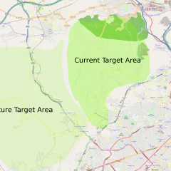
I always loved the idea behind OpenStreetMap. Mostly because of my open source experience and sites Wikipedia, these show that with enough people doing a little bit of work in the area they know, it is possible to create results which are better and more free than the conventional commercial offerings. I remember the time in London, when we had our little start-up and needed location maps for our customers and couldn’t find a good provider for this (there was no google maps or map24 at that time). So fools that we were we decided to write it ourself. We got the raw data on CD from TeleAtlas and one of our programmers got pretty far with a renderer. But before we could get anything useful map24 produced a much better version which we started using. But I always have been frustrated by the lack of open map data and open source renderers. With OpenStreetMap this is now all in the past, the maps are up to the quality of the commercial services in many areas now and the renderers are very good too. In fact the maps are so good that I haven’t really had a chance to contribute myself. But now with my frequent trips to Tibidabo with the mountain bike and my GPS phone I noticed that the OSM maps for that area are full of white spots and are missing most of the hiking and mountain bike routes through the forest, but also some of the tertiary roads. So I exported some of the tracks I had so far and uploaded them to OSM, this gives everyone working on OSM the chance to use these to create roads on the map. To do this I downloaded merkaartor, which makes it very easy to create roads and places and tag them correctly. There is a Fedora package available, so it was a very easy install. You can also use this to create maps even if you don’t have a GPS yourself, just by using the yahoo satellite images or tracks other people made public. Yesterday I did my first ride especially for OSM to trace some roads and tracks which I haven’t travelled with the GPS yet. It took me three hours to ride 30km, which was a lot of fun. One thing I found difficult is choosing the right tags for the roads and tracks. But it looks good at the moment and if it turns out to be incorrect it is always possible to change later. Here is an image of the area I am currently working on it is the whole Park de Collserola, around the Tibidabo. I have traced most of the small dotted lines in the current target area and some of the residential and tertiary roads. You can also see the same map on openstreetmap.org. Turns out this is probably one of the perfect hobbies for me at the moment, as it combines open stuff, mountain biking and gadgets. Now I somehow have to get some programming in there too.

September 27, 2009 · 3 min · Christof Damian
Nokia N79 Active

Nokia N79 Active

Recently I started using twitter, facebook and blogs more and I got a little bit annoyed that I couldn’t update those sites with my mobile phone. And then my digital camera died on me, which resulted in no new photos by me in the last couple of months. The final point which made me want to get a new fancy phone was me getting lost on Tibidabo without a GPS. My old phone is a Ericsson t39m, which is one of the best mobile phones ever made. It was one of the first phones with bluetooth and does stuff like email, WAP & T9. It also supports lots of accessories, like different sized batteries, different antennas, docks and travel chargers. It also pretty small and has a nice monochrome screen. But there comes a point where you need a new toy and after looking at all kind of phones I finally came up with a list of requirements: 3.5 mm headphone jackdigital camera > 3MGPSsmall and lightnot too expensive, because it might get stolen here in Barcelonanormal phone keys, no touch phonesome way to program for it WLANbluetoothUSB storage support for photos and music This ruled out pretty much most of the phones including the iPhone, which was out of the question anyway, because my recent experience with iPods and Linux. At one point I discovered the Nokia N79 Active, which was announced beginning of the year. It also has one nice additional feature which is was the real selling point for me: it comes with a Polar heart-rate belt. Buying one turned out to be a bit more difficult then I hoped. First it was just released in Finland, Sweden and South Africa, and not available on-line. It was announced in Germany, but the date got pushed back every month until they finally took it off their website. Then it got released in the UK and was available on the Nokia on-line shop, but they obviously don’t deliver to Spain. Finally a friend of mine in the UK ordered it for me and forwarded it to Barcelona. Now I have it since a little bit over a month and are fairly happy with it. I use it every day as my phone, for photos, web browsing and twittering. Together with the Nokia Sportstracker website and software it is also brilliant to track your sports activity, which is in my case mainly cycling and mountain biking. Here is the information about my last long ride on Tibidabo: 4h on Tibidabo Here are some other things I like about it: pretty light and small for a smart phonesome good software available, like GPS tracking (AFTrack), twittering (Gravity), Puttythere is a Python version for itsome nice google stuff, like Maps, Latitude, Youtube, …good Nokia mapping softwarethe podcasting client is nice and you can add your own OPML files as directoriescontacts & calendar can sync with googlecamera is good enough And some stuff that is rubbish the software and menus are structured very strange, you can reorder them but some stuff just makes no sense at all. The worst bits are all the different settings and preferences. Others think so too there is a “Media” button & menu, which doesn’t make any sense the whole Sportstracker thing seems to have a unsure future the WLAN and 3G selection should just do the right thing, like the iPhone doessome non-Nokia software has a completely different UI, the google apps and opera for exampleOVI (Nokia online services and app store) is a messit crashes sometimes, even doing simple stuffout of the box it comes with three different types of maps (google, OVI, Sportstracker)annoying start-up screen & sound and horrible ring tones Overall I am happy though, because I had rather low expectations as most mobile phones I had in my hand in the last couple of years were pretty rubbish. Except of the iPhone, which had the first good user interface for phones since the rotary dial, but it just was not right for me.

September 4, 2009 · 4 min · Christof Damian