I remember the time in London, when we had our little start-up and needed location maps for our customers and couldn't find a good provider for this (there was no google maps or map24 at that time). So fools that we were we decided to write it ourself. We got the raw data on CD from TeleAtlas and one of our programmers got pretty far with a renderer. But before we could get anything useful map24 produced a much better version which we started using. But I always have been frustrated by the lack of open map data and open source renderers.
With OpenStreetMap this is now all in the past, the maps are up to the quality of the commercial services in many areas now and the renderers are very good too. In fact the maps are so good that I haven't really had a chance to contribute myself.
But now with my frequent trips to Tibidabo with the mountain bike and my GPS phone I noticed that the OSM maps for that area are full of white spots and are missing most of the hiking and mountain bike routes through the forest, but also some of the tertiary roads.
So I exported some of the tracks I had so far and uploaded them to OSM, this gives everyone working on OSM the chance to use these to create roads on the map. To do this I downloaded merkaartor, which makes it very easy to create roads and places and tag them correctly. There is a Fedora package available, so it was a very easy install. You can also use this to create maps even if you don't have a GPS yourself, just by using the yahoo satellite images or tracks other people made public.
Yesterday I did my first ride especially for OSM to trace some roads and tracks which I haven't travelled with the GPS yet. It took me three hours to ride 30km, which was a lot of fun.
One thing I found difficult is choosing the right tags for the roads and tracks. But it looks good at the moment and if it turns out to be incorrect it is always possible to change later.
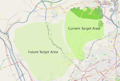
Here is an image of the area I am currently working on it is the whole Park de Collserola, around the Tibidabo. I have traced most of the small dotted lines in the current target area and some of the residential and tertiary roads. You can also see the same map on openstreetmap.org.
 Turns out this is probably one of the perfect hobbies for me at the moment, as it combines open stuff, mountain biking and gadgets. Now I somehow have to get some programming in there too.
You're right, choosing the right tag is not as important as getting a good GPS trace. The tags can always be changed later, but each new GPS trace adds extra value. Actually visiting, making a GPS trace and recording what is actually there, maybe with photos, notes or an audio or video recording is so much more valuable than just tracing from allowable aerial photos or importing from most PD sources.
ReplyDeleteOnce I got more traces in I will also work on the quality of the tags. I have to find out how other people track footways, tracks and singletracks first though.
ReplyDeleteOn the other hand: I noticed some roads being tagged as secondary when to me they are clearly tertiary. They didn't even have two lanes. The traces themselves where good though.